For decades threatened species like dugongs and turtles have been caught and killed in gillnets on the Great Barrier Reef.
In a win for our iconic wildlife, Queensland and Australian Governments have committed to phase out gillnet fishing from the World Heritage listed Reef by June 2027.
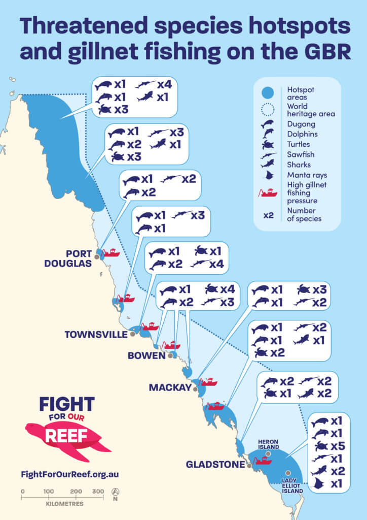
The latest mapping by AMCS and James Cook University identifies hotspots for protected species on Queensland’s east coast, and identifies where these species are at the most risk from commercial gillnet fishing.

Vital hotspots for many threatened species include Cape York, the Bowen-Whitsunday Region and the Gladstone-Capricorn Bunker Region. Yet these areas experience high fishing pressure.
About The Map
AMCS and James Cook University have pulled together decades of published research to map biologically important areas for threatened marine species, commercial gillnet fishing pressure and protected areas within the Great Barrier Reef World Heritage Area all in one place.
Biologically important areas are where we find key populations of our iconic wildlife or where they congregate to breed, eat and migrate. These areas are different for each species and so each one is represented in a layer in the map below. For each species we have categorised areas as being of high, medium, low or no importance, based on the best available information for the species.
The map also includes fishing data from the mandatory logbooks used by commercial fishers. We can then see where gillnet fishing pressure is highest on the Reef and how this overlaps with important areas for different species. Where fishing pressure overlaps with important areas is where there is the highest risk to threatened species.
Included on the map are areas of the Reef that already provide protection from gillnet fishing. This includes Great Barrier Reef Zoning, existing Net-Free Zones and Dugong Protection Areas.
More detail on the map and methodology is provided in the supporting report.
We need the Great Barrier Reef to be a refuge for species like dugongs, turtles and sawfish. This map is a vital resource for fisheries and Great Barrier Reef Managers, conservationists and the public to identify priority areas for conservation.
Explore the interactive map below. Toggle layers on or off using the button at the bottom right.
